 Go
Back
Go
Back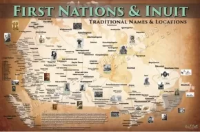


Poster: First Nations and Inuit Map
$34.50
Artists:
Size:
24 inches x 36 inches
Text Content Territories:
Indigenous Canadian; First Nations; Inuit;
Status: Available
Details:
This map is the most comprehensive ever created of the First Nations of Canada. It utilizes the original and true tribal names for each Nation and shows where each Nation was originally before contact. It includes the names of the Nations who survived this incursion, as well as those that did not, honoring the memory of those who have fought tenaciously to hold on to their homelands. It is a visual reminder of those who have called this land home since time immemorial, creating a sense of pride for Aboriginal peoples and a better understanding for all. To Indigenous peoples, this land will always be our ancestral homeland.
Additional Information
- Size: 24" x 36"
- Map by Aaron Carapella.
- Tribal Nations Maps is a Native-American-owned business.


